The February 1st Transport Committee has several massive reports on the future of transport and getting about in Edinburgh, much of which we strongly endorse. There’s a great twitter thread about them here.
However they are accompanied by a wholly unexpected proposal to remove cycling from a 2km Roseburn section of the North Edinburgh Network when the tram is extended to Granton – although a walking/wheeling path the same 3m width as the existing will remain.
We very briefly pick out high points from the documents at the end of this article but, first, we discuss the discouragement, or possible removal, of cycling from Roseburn corridor. The exact nature of the consultation on this is to be decided by Councillors imminently and it has therefore demanded much of the immediate attention of our Planning Group volunteers.
Cycling, the tram, and the Roseburn Route
1. Spokes has always supported the tram in principle, assuming holistic design in which cycling, walking and indeed bus are fully catered for. We see cycling as part of an overall sustainable transport and access strategy, not as single-issue.
For the avoidance of doubt, whilst Spokes would be very happy with a holistically-designed onroad tram route, and that would be much preferable for wildlife, we have never opposed the option of tram on the Roseburn route if that is very clearly shown to be the best public transport route, provided good cycling and walking conditions remain. Like it or not, it now looks likely that the tram will use the Roseburn corridor. The Council report is here.
2. A cycle/wheel/walk route beside the tram has always been considered feasible and desirable, from the original tram proposals in the early 2000s, right up to the present. For example, the 2006 Tram Design Manual (p90), “Cycle/pedestrian routes are to be provided alongside the tram track on those sections where the tram route follows a corridor currently occupied by a cycle/pedestrian path.” The existing path is 3m wide, and so is the proposed new path, albeit presumably with some significant pinch points.
3. The 2021 ESSTS Phase 2 report (table 5.5) proposed two path options beside the tram – they rightly rejected a ‘do minimum’ (B1a) on the grounds that it contradicted council active travel policy. Remarkably, the new council proposal is even less cycling-inclusive than that rejected ‘do-minimum’ option!
ESSTS also proposed a ‘do maximum’ (B1b), which admittedly looked costly. A ‘do medium’ solution should be feasible, dealing with pinch points by means such as possibly replacing just a few of the more problematic structures, possibly some single-track, and accepting a number of remaining pinch points. This should be maneagable in a £2bn project, particularly if the mitigations are fairly limited. We have given an example of ‘do-medium’ in an appendix below.
4. The onroad cycling ‘alternative’ proposed in the report is of course valuable in itself, but is not a valid alternative, with different connections and destinations, e.g. missing Craigleith Retail Park. Furthermore, it is certainly not of equivalent safety or attractiveness (e.g. Dean Bridge, Orchard Brae steep climb, junctions). Indeed, table 4.2 in Appendix 2 says of this onroad alternative, “provision would be worse towards Haymarket.” And whilst the Circulation Plan mentions a cycleroute ‘connection’ across Dean Bridge, the Plan also shows Dean Bridge remaining part of the general traffic network. In summary, it is far from clear what standard this ‘alternative’ would provide, and parts of it would likely not be the sort of route to attract a wide section of the population..
5. The North Edinburgh Network is well used for utility purposes, not just recreation. It is a complete misnomer to describe it solely or even largely as a ‘recreational route.’
6. Utility use will increase further once the Roseburn-Canal project is complete (a major aim of that £12.5m project) and in the future once a regular tram improves security on the route during hours of darkness.
7. A concern of the present route is ‘stranger danger’ for walkers and cyclists (largely during hours of darkness). Whilst a tram will somewhat allay these fears, removal of those cyclists who are content to use the path in the evenings will have the opposite effect, significantly reducing public surveillance for walkers and wheelers, particularly given the ability of cyclists to arrive quickly if they hear calls for help.
8. The TEC report says the impact of removing cycling would be ‘slight negative’ (table 4.2 in Appendix 2). This is ridiculous, as we can see from the immediate reaction on social media – it would be a major negative.
9. The TEC report is itself ambiguous. Table 4.2 in appendix 2 says “Cycle provision cannot be provided” beside the tram whereas 3.2.1 says “Cycling will be discouraged”
10. Cycling on footpaths is legal in Scotland, under Section 1 of the Land Reform (Scotland) Act 2003, with only a few exceptions which do not appear to apply here. So how would the Council either ban or ‘discourage’ cycling? – and would either be legal? Of course, under the Act, this right of cycle access must be “exercised responsibly.”
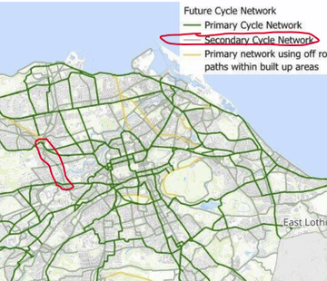
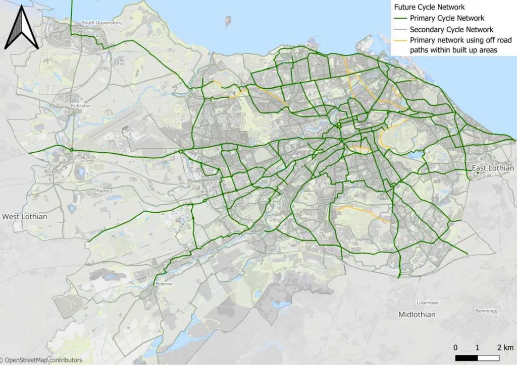
11. Finally, the Future Streets Circulation Plan (TEC report 7.2) outlines the future city cycle network (see ‘Future Streets’ cycle network‘ below) with segregated ‘primary’ routes on major roads and ‘secondary’ linking routes largely offroad or on minor streets. The Roseburn path rightly forms an important link in this secondary network (see map below), being vital for both utility and recreation. Councillors passing this report and the tram report unamended would be contradicting themselves and giving absurd instructions to officers – to discourage or even ban cycling on a route they have defined as part of the city’s cycle network!
Construction period
On a separate but vital issue, if the tram uses the Roseburn route there will be a closure period of years for construction. Alternative cycling provision, as good as possible, must be made before contruction begins (the Leith extension example is not encouraging!) Again, this should cover all destinations connected by the Roseburn path (e.g. Craigleith Retail Park) not just an end to end connection. Cycling is about local access, as much or more than about long distance trips.
What you can do
- Please email your councillors urgently if the above concerns you. Ask them to raise your concerns with their party transport representative.
- Find your councillors here (use the postcode tool on that page if you don’t know your ward)
- The main issue is what will be in the public consultation – at present it is intended to be solely about the Roseburn option (with onroad tram ruled out), and with the replacement 3m path beside the tram being for walking and wheeling only. In our view the consultation should take it as a given that the replacement path will be designed for and open to cycling as well as walking and wheeling.
- Retweet our tweet.
The new ‘Future Streets’ policies
The Transport Committee papers for Feb 1st are here, the main ones being…
- 7.1 City Mobility Plan 1st Review This includes the entire Active Travel Action Plan (ATAP) as appendix 6 !
- 7.2 Our Future Streets a circulation plan for Edinburgh and part2 Including what modes will have priority on what streets; ‘liveable neighbourhoods’; and a proposed cycleroute network map
- 7.3 Tram from Granton to BioQuarter and Beyond Consultation for Strategic Business Case Development Includes the proposal to remove cycling from 2km of the North Edinburgh Network (although, bizarrely, it is part of the cycleroute network map in 7.2 above!!)
- There’s also a 42MB pdf combining all the Committee reports [page numbers below refer to this]
For a very brief overview of salient points from these documents, see this Edi.Bike newsletter. Just to pick out a few items of particular interest…
- The ‘Future Streets’ cycle network [p413] comprises a largely segregated primary network on main roads – a great commitment for which we have long argued. Also a secondary network (including existing offroad routes) which links primary routes to many destinations and provides great recreational opportunities. We have not had time to scrutinise the detail.
- A8 Roseburn to Gogar: “an integrated street upgrade as a key corridor from Roseburn to Gogar, incorporating a transformation of St Johns Road as a shopping street for people, better provision for people walking/wheeling, protected cycling infrastructure and measures to improve bus journey times and reliability.” Extending CCWEL in this way at an early date was a priority in our comments [para 3.3] on the 2023 ATAP consultation
- Removal of through general traffic from the Bridges corridor (alongside the Granton to Bioquarter tram)
- Removal of through general traffic from the Cowgate and Canongate with initial steps in 2024
- Liveable Neighbourhoods across the city, though worded rather cautiously, probably given the ructions there have been over some (but not all) existing & past projects
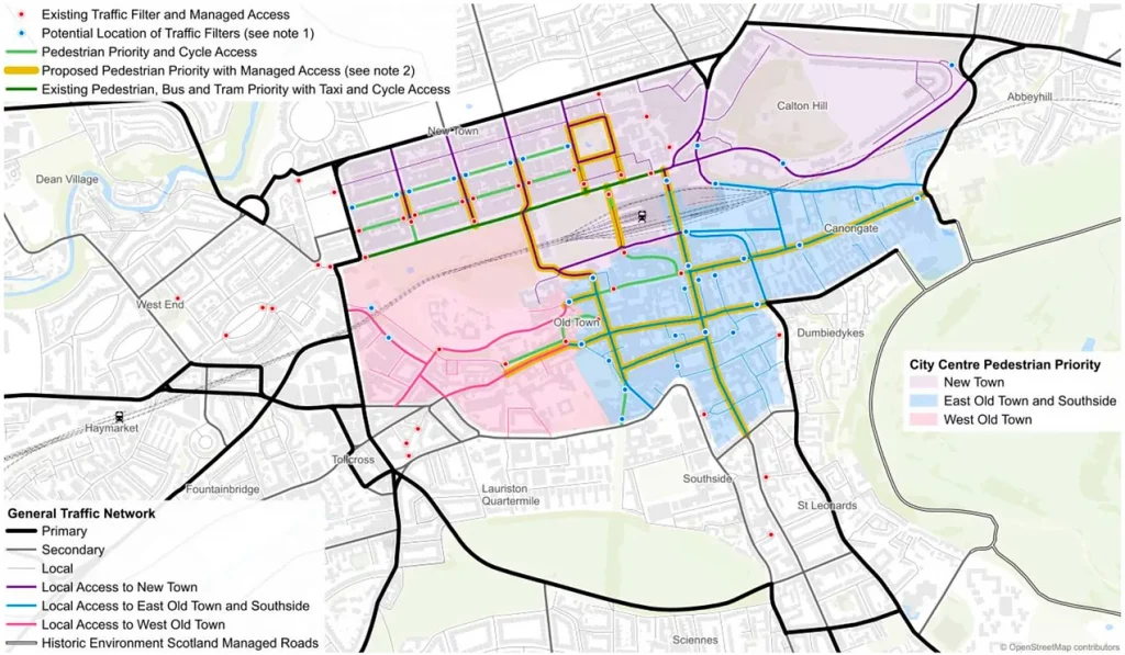
- City Centre Transformation ‘Option C’ upgrade [p446] to “create an extensive area between Lothian Road, Lauriston Place, Holyrood Park and Queen Street and without general through / car traffic”. Much use of modal filters (see dots on map)
- Timescale The Council has a (deserved) reputation for implementation slowness or not happening at all. Thus it is great to see action promised on traffic reduction in Cowgate this year, and a rapid start to design of the A8 corridor (above). There will doubtless be more on timescale promises buried in the documentation, when we eventually get through it!
Appendix: Providing for cycle/wheel/walk beside the tram
In bullet point 3 of the article above, we suggested a ‘do medium’ approach. Whilst we are not engineers, here is the sort of approach that might be considered…
- Coltbridge Viaduct, Ravelston Dykes overbridge, Queensferry Rd overbridge: major structures, where the cost of a replacement structure would be unreasonable. Options might be single-track operation, modifications to the structure (e.g. path attached beside the viaduct) or accepting a pinch point
- A8, Craigleith Drive, Groathill Road South: possible extra active travel bridge
- St George’s school bridge: not sure here – the bridge may be listed
- Path width: there may well be scope to widen the path to 4/4.5m for most of the way, possibly enabling a path segregated between walking and cycling, thus enhancing current provision! This could be helped by raising the bottom of some cuttings, and lowering the top of some embankments, to widen the floor area.