Since 2006 Spokes has been counting cyclists and other vehicles during the morning rush hour, in May and in November, on Lothian Road and at Forrest Road [very occasionally also on other routes or other types of survey]. All the data, together with a file of trends, is downloadable below.
Contents
Interpretation of count data
Often the results of our counts are misinterpreted in the press and in online comments. Here, therefore, is a statement of what our counts do and don’t tell you, together with details of other relevant data sources.
What our counts tell you
- Numbers of cyclists, private cars and ‘commercial’ vehicles (van, bus, taxi, etc) in both directions on 2 important roads into the city centre during morning rush hour, in May and November each year
- Trends in the above over the years
What our counts don’t tell you
- Total numbers of bikes (or other vehicles) entering the city centre.
- Total number of people (as opposed to vehicles) using the routes we count. This is similar to the council cordon counts, which also count vehicles. Counts of people numbers would be nice but it would be quite impossible for us to count numbers of people in buses, vans and cars (as well as pedestrians). We do however count the number of cars which are (or appear to be) single-occupant.
- Changes over the years as between different approaches to the city centre (e.g. are there more cyclists from X direction but no change from Y direction).
Other data sources
- Edinburgh Council has automatic bike counters at many locations in the city, both offroad and onroad. In 2016 this data was at last made publicly available on the Council’s new opendata web pages [2025 – the former web link no longer works – we can now only find a open spatial data portal – but see the next bullet point]. Some historic count data can also be found in the Council’s excellent Streets Ahead Cycle Incident Analysis Report 2004-2010.
- Cycling Scotland hosts an Open Data Portal for cycling-related data from across Scotland. This covers not just their own automatic counters (sited across Scotland, including some in Edinburgh) but many other data sources, including from Edinburgh’s traffic counts.
- The Council did regular ‘cordon counts’ of all traffic entering the city centre [CEPATS] – this data was not publicly available. We are not clear whether CEPATS still exists, has now transferred to automatic counters, or whether manual cordon counts still take place.
- There is also government cycle-use data for A-roads – however note that sample sizes are small at council level, so big fluctuations are expected; and ofcourse A-roads are not representative of everyday bike trips on the ordinary local road and path networks. Nonetheless the data ties in with our results of rising bike use and slowly declining car use over the last few years
- Sustrans has over 1000 automatic counters on offroad paths in the UK, including several in Edinburgh area. Sustrans publishes national annual reports [e.g. The Real Cycling Revolution, 2012 (pdf 2.3MB). News release] based on data from the counters and other research methods. Data from local counters should be available from council cycling officers, who receive it from Sustrans.
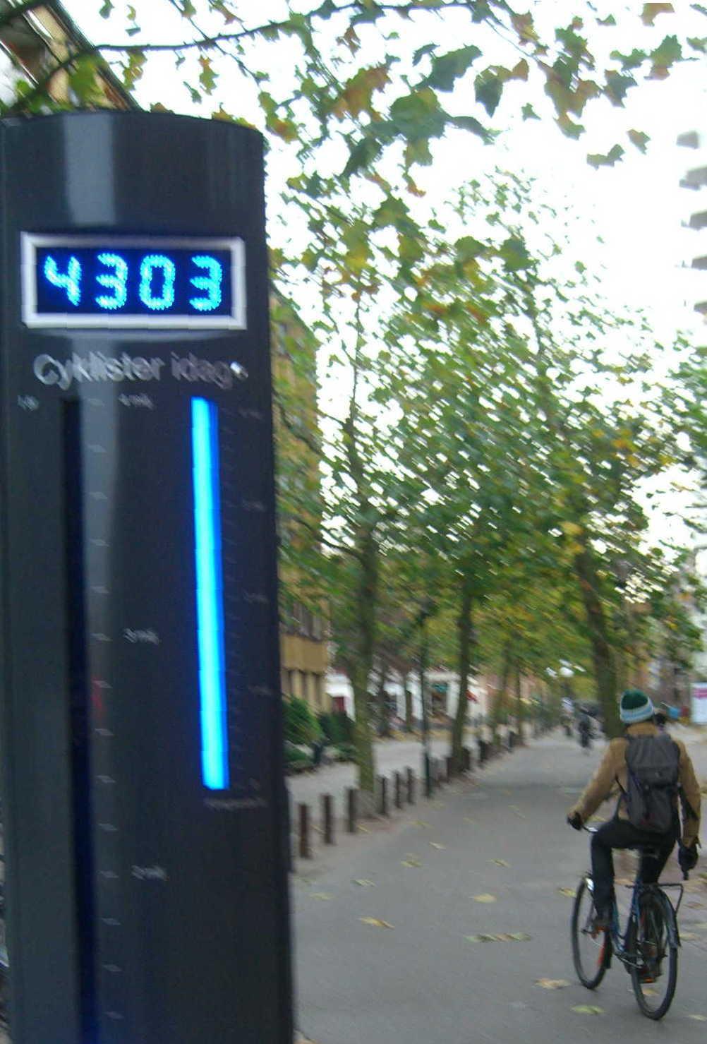
- For years Spokes pressed Edinburgh Council for a European-style Public Bike Counter [picture], ideally on Middle Meadow Walk – for its promotional value as much as for the actual data! At long last it happened in 2014 – as part of a wider counter project in several parts of Scotland, coordinated by Sustrans, but the project seems to have closed and the public counter is, sadly, no more.
- Cyclestreets bike data map. New facility [2017] with many types of data including collisions, strava, traffic counts, theft, etc. When using, check carefully the source and years of validity for each type of data.
- See also our census data page.
Data from Spokes main cycle and traffic counts
Note – if the Excel files below do not open directly, save them to your PC and try opening them from there.
Trends in Spokes traffic counts Lothian Rd + Forrest Rd, November 2006 to the present [xls]. Note: you may need to ‘unhide’ certain columns if not all you want is immediately visible
2511 Traffic count 11.11.25 Wet forecast and lunchtime downpour, so big drop in lunchtime bikes [no Porty count this time] / Full data / Article / Bluesky /
2505 Traffic count 13.5.25 Modest rises in bike use, reaching the highest % (of all vehicles) post-covid, at both 8.00-9.00 and 12.30-13.30. Porty count similar / Full May 13 city centre data / Porty count data / Porty trends / Article / Bluesky /
2411 Traffic count 12.11.24 Bikes up somewhat, but bigger rises where new infrastructure. Cars up, despite LEZ. Good results in Porty count / Full Nov 12 city centre data [xls] / Porty count data [xls] / Porty trends [xls] / Article / Bluesky / tweet /
2405 Traffic count 14.5.24, full data [xls] Bike % same as May 23, though bike & car numbers both down. Bikes up on Nov 23, cars down. In comparison, big bike rise at Omni segregated bike lane / Porty count – bikes & % up compared to May & Nov 23 / article / tweet /
2311 Post-covid traffic count 7.11.23, full data [xls] Small shift bikes-up, cars-down in city centre; little change in Porty / article / tweet /
2305 Post-covid traffic count 16.5.23, full data [xls] Substantial post-covid bike rise continues in city centre; cars static. But little change in Porty. Separate South Edinburgh bike-only count.
2211 Post-covid traffic count 9.11.22 Full data [xls] Post-covid bike rise continues, particularly citybound 8-9am. Worrying car rise in Porty / article / tweet
2205 Post-covid traffic count 17.5.22, full data [xls] Post-covid bike rise continues. Decline in car numbers but this may be for a temporary reason and actual trend is static or small rise. Article Tweet
2111 Covid traffic count 21.11.02 – full data [xls] Bike % rises modestly from first 2 covid counts. Car rise seems to have ended with the 2105 count. Article Tweet
2105 Covid traffic count 11.05.21 – full data [xls] Results drastically affected by covid pandemic. Summary. Now includes Porty count at Brighton Place as well as our regular city centre counts
Impact of Covid Further to the summary document above, note this Transport Xtra article, middle graph, showing covid impact in Inner London – bike use falling significantly in peak (which agrees with our counts in Edinburgh) and rising signficantly for the rest of the day (which we don’t count!) London article also scanned as pdf. The subsequent December 2021 TfL Travel in London report confirms and expands on this – see pages 106-7.
2011 Covid traffic count 10.11.20 – full data [xls] Results drastically affected by covid pandemic. See article.
1911 Traffic count 12.11.19 – full data [xls] Cold morning with cold showers, also following a cold wet day. Bike numbers down on last November [lovely weather] by about 13%. Interesting comparisons with other wet November counts (2015 & 2006) – see article. Single-occupancy car use appears to peak on such days, although total car numbers continue their gradual decline.
1905 Traffic count 14.5.19 – full data [xls] Nice sunny day and week. Marginally continuing the trends of more bikes and fewer cars, though not yet returned to the 1705 peak numbers, which fell in 1805 when Leith Street was closed to cars but open to bikes. Southbound oddity – a substantial drop in southbound bikes at Forrest Rd, but more than balanced by substantial rise in southbound bikes at Lothian Rd. Note that count is 2 weeks later than last year, and getting close to University exam period & fewer classes.
1811 Traffic count 13.11.18 – full data [xls] Dry, pleasant early winter day. Highest ever November bike %, but only a slight improvement on November 2017. The % increase is due mainly to lower citybound car use, with only a marginal rise in bike numbers. Good results at Lothian Road, but slight decline at Forrest Road. Blog Tweet.
1805 Traffic count – full data [xls] Cold but sunny nice-looking day. Puzzling results. Count was 1 week earlier than recent years. Bikes down at all 4 count points. Cars also down at Forrest Rd, but up at Lothian Rd and, due to the latter, bikes lower as % of all traffic. Leith St has been closed to motor traffic (open to bikes) in 1711 & 1805 counts, so one might expect a rise in motor traffic and fall in bikes at Forrest Rd, but cars actually fell.
1711 Traffic count – full data [xls] Dry, pleasant early winter day. Total car numbers up at our 4 count points, probably due to the 10-month total closure of Leith Street, but still the 2nd lowest ever. Also a rise in number of bikes, though the total no. of bikes is slightly below the November figures during the massive tram-building road disruptions of 2011-2014. As a % of all traffic, bikes rose marginally compared to last November. Blog Tweet
1705 Traffic count – full data [xls] Pleasant spring morning after series of good days. Highest bike numbers ever, and a continuing fall in car use. Citybound traffic falling greatly (particularly at Lothian Road) though with southbound up somewhat. All categories – car, commercial and bike – following that pattern to a greater or lesser extent. Blog Tweet
1611 Traffic count – full data [xls] Dry, pleasant early winter day. Slight increase in number of bikes compared to last November, though the total no. of bikes is slightly below the November figures during the massive tram-building road disruptions of 2011-2014. However, further significant fall in cars, to the lowest ever, making bikes the highest % ever of all vehicles. The big fall in cars was almost entirely at Forrest Road (both directions), with only a small fall at Lothian Road. Blog Tweet.
1605 Traffic count – full data [xls] Lovely sunny day – highest ever number of bikes, lowest ever number of cars. Approx 1 in 4 of all vehicles citybound were bikes, with 22.7% even on Lothian Road. Mystery – the increase was entirely citybound, with a small decrease southbound, and the biggest car fall was southbound also. More info: news item tweet.
1511 Traffic count – full data [xls 45k] The wettest, dreichest day we have ever counted on, also following 2 very wet and windy days. Probably as a result, bike numbers down 11% on last November. Despite the weather, car numbers were also down, by 7%, to their lowest level ever. Perplexingly, southbound bikes were the highest ever, whilst northbound fell significantly, although cars fell in both directions. More info: news item, tweet.
1505 Traffic count – full data [xls 45k] Unfortunately a cold and windy day, though dry. Slight fall in total number of bikes compared to our sunny count in May 2014, with a big drop Lothian Road northbound outweighing smaller rises at the other 3 count points. However, private motor traffic fell even more, and bikes as a % of all traffic were the highest ever, at 16.5%. More info: news item, tweet.
1411 Traffic count – full data [xls 46k] Total figures almost identical to Nov 2013: bikes 9-10am up from 483 to 484!! but bikes up about 30 at Forrest Road (northbound+southbound) and down about 30 at Lothian Rd; motor traffic slightly up at both locations. Note this is first count when Meadows counter has been in place. Bikes 15.8% of all vehicles, unchanged from Nov 2013.
1405 Traffic count – full data [xls 46k] Highest ever bike total and lowest ever car count. Forrest Rd – bikes up and cars down significantly in both directions. Lothian Rd – bikes up and cars down northbound, but the opposite picture southbound – why? More comment in full news report.
1311 Traffic count – full data [xls 45k] Highest ever bike total [Nov or May]; Lowest ever November car count. Lothian Rd – bikes up (over 20% of northbound vehicles!) and cars down – may relate to Haymarket reopening. Forrest Rd – cars & commercial vehicles up significantly, bikes slightly down – impact of extra traffic appears to outweigh any benefit from QBiC. See full news report.
1305 Traffic count – full data [xls 37k] Worse weather than last May, but highest ever no. of bikes (just). Huge car rise at Forrest Road (up 33%) though overall car count total still less than in our 2007/2008 counts. Probable car transfer from Bridges & Lothian Rd to Mound, which is now reopened to all traffic (also more car restriction at foot of Lothian Rd, as access now closed to QF St). Bikes up slightly in Lothian Rd, but almost static in Forrest Rd. No obvious gain from QBiC, though it may have helped maintain bike numbers given the deterrent effect of the huge Forrest Rd car increase.
1304 Mini-count Princes St / George St [pdf 50k] A special one-off count to use in our campaign to counter the council’s proposed Princes Street bike ban.
1211 Traffic count – full data [xls 37k] Despite drizzly weather, highest ever 8-9am number and % of bikes, just higher even than the May count. Significant rise on new Quality Bike Corridor northbound. Overall northbound rise but southbound fall. Cars almost lowest ever November figure, but southbound car transfer from Lothian Rd to Forrest Rd (presumably due to Mound reopened).
1205 Traffic count – full data [xls 37k] Highest ever total and % of bikes, cars almost lowest ever May level, but taxi/bus/commercial if anything rising.
111115 Traffic Count – full data [xls 36k] Big jump in bike use – total bikes higher than any previous count including May counts! Bikes 8-9am up 12% on Nov 2010 and 15% on Nov 2009. Cars at lowest ever November level, though drop partly due to Mound closure (as in Nov ’08 & ’09). Bikes now form 20% of all northbound 8-9am vehicles at our counting points. The Bike Station also did counts today – and found similar big rises in bike use.
110517 Traffic Count – full data [xls 36k] Comparison with May 2010 unreliable because Queensferry St shut for gas main work, with traffic diverting via Haymarket (& Forrest Rd)? Lothian Rd – big fall in motor traffic, lesser fall in bikes. Forrest Rd – cars up, bikes same as last year. Overall, bikes comprise 19.7% of 8-9am citybound vehicles, whilst 77% of citybound cars have only one occupant.
101116 Traffic Count – full data [xls 44k] Increased bike traffic for the 5th successive November. But, exactly as in May, whilst bike traffic rises at 3 count points, it falls in Forrest Rd heading towards Princes St – have the tramlines deterred some? Unlike May, private motor traffic rose substantially (but only significantly at the above location), resulting in a slight fall in bikes as a % of all traffic. On Nov 16 there was also a count at Fiveways Junction [pdf 135k], by the Bike Station.
100511 Traffic Count – full data [xls 20k] Increased overall bike traffic for the fourth May – very small increase this time, but against a background of continuing fall in cars, so the % of bikes continues to rise. Fall in Forrest Rd bike traffic towards Princes St – have the tramlines there deterred some? See May 11 news item for more comment.
091117 Traffic Count – full data [xls 20k] Increased bike traffic for the fourth November – very small increase this time, but against a background of continuing fall in cars, so the % of bikes continues to rise. Highest ever November bike % on any road, 23.9% northbound on Forrest Rd, but fall in bikes on Lothian Rd.
090512 Traffic Count – full data [xls 20k] (1) Continuing consistent high bike use, plus rise in numbers since last May at every point, though % fall in Lothian Rd due to more cars (2) Overall drop in motor traffic, with big Forrest Rd southbound car reduction (due to Mound closure?) but big rise on Lothian Rd (less traffic restrictions now at West End).
081118 Traffic Count – full data [xls 20k] (1) Continuing consistent high bike use, with overall rise since last Nov (2) Big Forrest Rd southbound car reduction (due to Mound closure?) along with rise in bikes and in car sharing.
080506 Traffic Count – full data [xls 21k] Continuing consistent high bike use, around 20% of all vehicles citybound 8-9am. Also counted single occupancy cars – around 75% of all cars!!
0712 Middle Meadow Walk cyclist questionnaire survey. Cyclists were stopped and asked if they would answer a few questions. MMW questionnaire [doc 18k] MMW Raw data [xls 28k] MMW Results graphs [doc 400k]
071120 Traffic Count – full data [xls 27k]
070515 Traffic Count – full data [xls 17K]
070515 Traffic Count – Press Release [rtf 24k]
061128 Traffic Count – full data [xls 75K]
061128 Traffic Count -Press Release [rtf 13k]
Graphs of trend data] thanks to Chris Fleming [@chrisfl on twitter] [May not be up to date]. Note the following…
- The graphs sometimes take a few seconds to appear
- Moving the cursor to any point on a graph will give you the date and count for that point [the colour tells you whether the data refers to bikes, cars or commercial]
- You can hide or display data for each transport mode by clicking that mode in the key. For example, to see just bike figures, click private (cars) and commercial, to hide that data. If you do this in the final graph (total of all count locations) you will see clearly the overall growth in bike numbers and decline in cars.
- An interesting point is how little it seems to matter whether it is May or November!